
Advocacy Timeline

From 1985 to 1992, Wilderness Trail Bikes (WTB) advocacy focused on bicycle access to trails in Marin County’s parklands and open space. At the time, there were efforts to ban bicycles from using Marin’s extensive trail system, and WTB fought for more inclusive policy that recognized the rights and responsibilities of trail users on both foot and bicycle. Also during this period, WTB President Patrick Seidler formed the King Mountain Open Space Association with the goal of stewarding King Mountain in Larkspur from private ownership to public open space.

In 1993, WTB-TAM President Patrick Seidler published the two-part “TRAILGATE - A New Paradigm” with two articles in the The Coastal Post. These articles, “Intra-County Transportation” and “Bicycle Freeways,” were the catalyst that launched WTB into decades of advocacy on behalf of transportation alternatives. Seidler traces the evolution of Marin’s 18th century railroad lines, showing how the rail lines followed the most efficient path between towns. Seidler laid out a vision where modern-day “bicycle freeways” or bike paths serving intra-county commuters followed the routes of the old railroads, leading to a new paradigm for intra-country transportation.

In 1994, the Marin County Department of Parks, Open Space and Cultural Services published the Marin County North - South Bikeway Feasibility Study (part 1 | part 2). This was the first Marin County government-approved document to formally and in detail lay out the alignment for what would later become known as the “North - South Greenway.” Seidler, fresh on the heels of the Coastal Post articles, was invited to join the Ad Hoc Committee on Bicycling. Together, the group put forward the conceptual engineering for a county-spanning bike path from Sausalito to Novato that more-or-less followed the vision in the Coastal Post articles by following the historic Northwestern Pacific Railroad right-of-way. Over the intervening decades, many segments of this system have been built, but gaps still remain. To this day, completing the North - South Greenway is still WTB-TAM’s top goal.

In 1996, Marin County voters were asked to decide on Measure A. This self-imposed sales tax would be used to fund improvements in Marin County Parks and Open Space, but would do nothing to improve access to trails by bicyclists. In response, prominent bicycle advocates, racers and industry members co-signed The Declaration of Inter-Dependence was signed by prominent bicycle advocates, racers and industry members, and published in the Marin Independent Journal to declare opposition to taxation without representation, and to detail the offenses suffered at the hands of entrenched opposition.

In 1997, WTB-TAM formally became a 501(c)3 non-profit organization, known by its name at the time TAM, or “Transportation Alternatives for Marin.” In its first two years, numerous “Bicycle Breakfasts” were held to educate elected officials about existing bicycle and pedestrian plans, initiatives and opportunities. Also this year, WTB opened its first European office in Maastricht, Netherlands. From this ideally-located European home base, WTB-TAM would learn from the Dutch masters of international best practices in bicycle path design.
Following the failure of Measure A, the Marin Sonoma Vision Workshop brought elected officials, engineers, and transportation advocates together to diagnose regional transportation problems. At the same time, WTB-TAM organized the Coalition for Balanced Transportation, a coalition of environmental activists, business owners, and bicycle advocates who organized grassroots support and successfully lobbied to get the North - South Greenway included in 1998’s Measures A and B, which were the outcome of the Marin Sonoma Vision Workshop. In total, Measures A and B would have allocated $300 million for transportation, including $10 to $15 for bicycle transportation. This was the first time the North - South Greenway was included in any formal planning and would-be funding process. This was the beginning of WTB-TAM’s relationship with members of the Marin County Board of Supervisors. Although Measures A and B failed to win voter approval in 1998, the experience taught WTB-TAM valuable lessons that would later be utilized in the passage of other legislation to fund bicycle transportation.
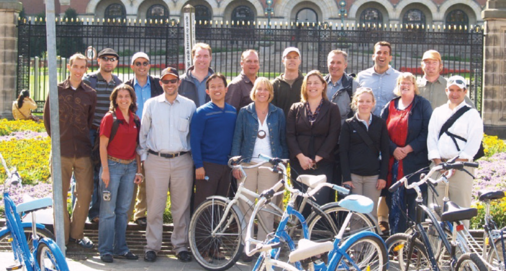
In 1998, WTB-TAM uses its European office location in Maastricht, Netherlands to launch the first of what would be many International Study Trips. This first trip brought Marin County Supervisor Steve Kinsey, SMART Engineer Ken Eichstaedt, and County Engineer John Kress, amongst others, to the Netherlands to see with their own eyes and experience with their own feet the best bicycle infrastructure in the world. Graduates of the subsequent 12 International Study Trip that WTB-TAM spearheaded have gone on to serve as Public Works Directors, Mayors, and State Legislators.

In 1999, Congressman James Obserstar (D-MN) laid out his vision for bicycle infrastructure in the United States at the Sea Otter Classic. WTB-TAM first forged ties with the Congressman at this event, a relationship which would prove to be fruitful in the coming decade. In 2000, Patrick Seidler’s other non-profit “Bikes Belong” (now “People for Bikes”) recommended a Safe Routes to School program and Non-Motorized Transportation Pilot Program to Congressman Oberstar. At the same time Seidler, in conjunction with Marin County Bicycle Coalition Executive Director Deb Hubsmith, co-authored the White Paper laying out the vision and plan for the National Safe Routes to School program.
Beginning in 1999 and lasting more than a decade, WTB-TAM conducted extensive grassroots work to ensure that construction of the segment of the North - South Greenway between Mission Avenue in Downtown San Rafael and Puerto Suello Hill was included in the Caltrans Highway 101 HOV Gap Closure Project. One of WTB-TAM’s crowning achievements in this project was the conceptual engineering of the grade-separation of the North - South Greenway through the Lincoln Avenue interchange. The project designers said it could not be done, but Seidler demonstrated how it was possible to thread the Greenway through a tunnel underneath the freeway ramps, and to the top of Puerto Suello Hill in a trench between Lincoln Avenue and Highway 101. Today, the grade-separated pathway at Lincoln Avenue interchange serves as a model that projects designers are looking to apply at other interchanges along Highway 101 in Marin. The project cost $10 million and was completed in 2010.

In 2001, WTB-TAM organized a “Congressional Bicycle Breakfast” with Congressman Oberstar as the keynote speaker. Oberstar delivered a thunderous speech, ending with the proclamation that “If I were King, I would make Marin County the capital of the bicycle!” Shortly thereafter, Representative Oberstar introduced the Pedestrian and Cyclist Equity Act of 2003 (PACE), which would fund Safe Routes to School, create more bikeable and walkable communities, and fund pilot communities for non-motorized transportation, modeled after programs in the Netherlands. PACE would ultimately incorporated into the Transportation Re-Authorization Bill of 2005.

In 2002, WTB-TAM started working with the Alto Tunnel Steering Committee to reopen the Alto Tunnel for bicycle and pedestrian use. The Alto Tunnel was originally built as a railroad tunnel in 1884. It is a key segment of the North - South Greenway, and the only flat route between Mill Valley and Corte Madera. More than two decades later, WTB-TAM is still fighting, along with other community groups, to reopen the Alto Tunnel.

In 2002, WTB-TAM joined the SMART Pathway Bicycle Pedestrian Planning Advisory Group. The following year, The Sonoma Marin Area Rail Transit District (a.k.a. “SMART”) was incorporated. WTB-TAM initiated the concept of building the SMART Pathway (a.k.a. the North - South Greenway) in or alongside SMART’s right-of-way parallel to the train tracks. Working in cooperation with SMART’s engineering team, WTB-TAM came up with the engineering methodology that allowed SMART to demonstrate how the pathway could fit within, alongside, or nearby the railroad right-of-way for the entire 71 miles between Larkspur and Cloverdale.

In 2004, WTB-TAM served on the Advisory Committee for the National Park Service Comprehensive Transportation Management Plan for Parklands in Southwest Marin. This study looked at transportation improvements in Muir Woods, Muir Beach, Mount Tamalpais State Park, Stinson Beach, Tennessee Valley, and the Golden Gate National Recreation Area. Together with bicycle visionary Joe Breeze, Patrick Seidler came up with the design vision for a bicycle and pedestrian tunnel between Haypress Meadow in Tennessee Valley and Green Gulch near Muir Beach.

On August 10, 2005, President George W. Bush signed the Federal Transportation Re-Authorization Act into law. Known officially as the “Safe, Accountable, Flexible, Efficient Transportation Equity Act: A Legacy for Users” or SAFETEA-LU for short, this is the legislation that formally established the National Safe Routes to School Program. It also established the Non-motorized Transportation Pilot Program, in which four communities were selected to participate: Columbia MO, Minneapolis-St. Paul MN, Sheboygan County WI, and Marin County CA. WTB-TAM played a crucial role for paving the way for SAFETEA-LU, and in fact wrote much of the language of the bill itself, which it shared with the bill’s author, Congressman James Oberstar (D-MN). In total, SAFETEA-LU funded $4.5 billion for bicycle and pedestrian transportation in the United States.

In 2006, the voters of Marin and Sonoma Counties narrowly defeated Measure R, the proposed sales tax measure that would have funded construction of the SMART railway. WTB-TAM believed that Measure R failed because it included funding only for partial completion of the SMART Pathway (a.k.a. North - South Greenway). The SMART District returned two years later with another proposition for voters: Measure Q. This time, following WTB-TAM’s advice, the measure promised to pay for completion of all 71 miles of the SMART Pathway from Larkspur to Cloverdale. This time, the voters approved the measure, and for the first time, SMART and the SMART Pathway had a dedicated funding source. To this day, WTB-TAM monitors SMART’s progress on the SMART Pathway, and continues to fight to make sure SMART honors its 2008 promise to the voters.

Another champion of bicycle transportation in Washington was Congressman Earl Blumenauer (D-OR), who in 2010 introduced the Active Communities Transportation Act, or “ACT” for short. The ACT Act proposed to allocate $2 billion to expand the Non-Motorized Transportation Pilot Program from the original 4 communities to 40 communities, with $50 million for each of 40 communities. The original 4 communities would have been included in the 40, which means Marin would have gained an additional $50 million for bicycle transportation. Unfortunately, President Barack Obama did not sign the bill into law. Obama later recounted in his memoirs that his failure to sign this bill, and infrastructure bills in general, was one of the greatest regrets of his presidency.
As a result of Marin’s inclusion in the 2005 Federal Non-Motorized Transportation Pilot Program, almost every city in Marin County got an updated Bicycle and Pedestrian Master Plan, and several planning studies were undertaken to determine the feasibility of corridor-wide bicycle improvements. One of those studies was the 2010 Fairfax to San Rafael Cross Marin Bikeway Feasibility Study by Alta Planning. This study laid out an east-west bicycle route connecting Fairfax and San Anselmo to the most populous city in Marin County, San Rafael. Today, the route laid out in this 2010 Study is still considered the alignment of the Cross - Marin Bikeway, which together with the North - South Greenway is part of Marin County’s primary bikeway network. Portions of the Cross - Marin Bikeway have been completed, notably in San Rafael, but gaps still remain, particularly in San Anselmo and Fairfax.


WTB-TAM led the fourth International Study Trip to the Netherlands and Germany in 2005. Delegates included Marin County Supervisor Charles McGlashan; MCBC Executive Director Deb Hubsmith; Alta Planning CEO Michael Jones, Tom Wilson, and Carole Misseldine.

WTB-TAM led the fifth International Study Trip to the Netherlands in 2006. Delegates included representatives from each of the four communities selected for the Non-Motorized Transportation Pilot Program, including mayors, engineers, advocates, and private sector professionals. Also among the delegates were members of the Rails to Trails Conservancy senior leadership and planners from the Federal Transit Administration.

WTB-TAM helped initiate and was an active participant in the Greenbrae Corridor Project. This project would have widened Highway 101 and created a massive new freeway interchange. TAM helped organize community activists to oppose the freeway widening project and advocate instead for improvements to bicycle and pedestrian infrastructure, including closing gaps through the area in the North – South Greenway. The Greenbrae Corridor Project was eventually abandoned, but WTB-TAM continues to work in this corridor because the gap in the North – South Greenway (now known as the “Southern Segment”) is still incomplete to this day.

WTB-TAM convinced the owner of the Northgate Shopping Center in San Rafael to install a multi-use path around the perimeter of the shopping center, and to implement a model based on the Indiana Cultural Trail. This model featured mode separation of bicycles and pedestrians and was the first of its kind in Marin County. WTB-TAM also convinced the shopping center to use a Dutch method of designing a setback for pathway crossing, leaving one car length between the pathway crossing and the intersection. This design improves safety and reduces the number of decisions that motorists must make simultaneously by allowing the motorist to watch for crossing bicyclists and pedestrians first, then to watch for cross traffic cars after clearing the pathway crossing. WTB-TAM has since advocated this Dutch method (also used in modern protected intersections) elsewhere on Marin’s road system.

WTB-TAM led the sixth International Study Trip to the Netherlands in 2009. Delegates once again included representatives from each of the four communities selected for the Non-Motorized Transportation Pilot Program. Delates included mayors, planning directors, bicycle pedestrian program managers, advocates, and city engineers. Also among the delegates were members of the senior leadership of PeopleForBikes and the chief engineer and Deputy Chief Secretary of Transportation from Taipei, Taiwan.

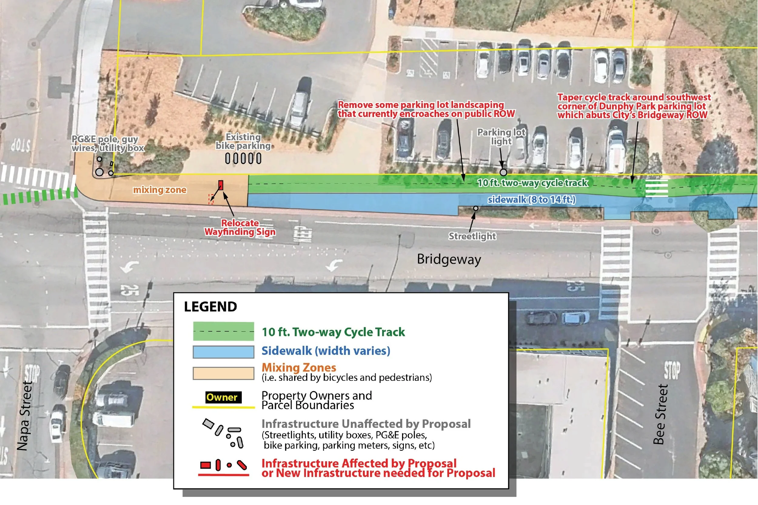
WTB-TAM began working with the City of Sausalito, Sausalito activist Beatrice Seidler, and other Southern Marin stakeholders on preparation of the Ferry Terminal to Gate 6 Road Pathway Feasibility Study. This study, funded by the Non-Motorized Transportation Pilot Program and published in 2011, would form the basis for a key section of the North – South Greenway in the City of Sausalito, one of the most heavily used bicycle routes in Marin County.
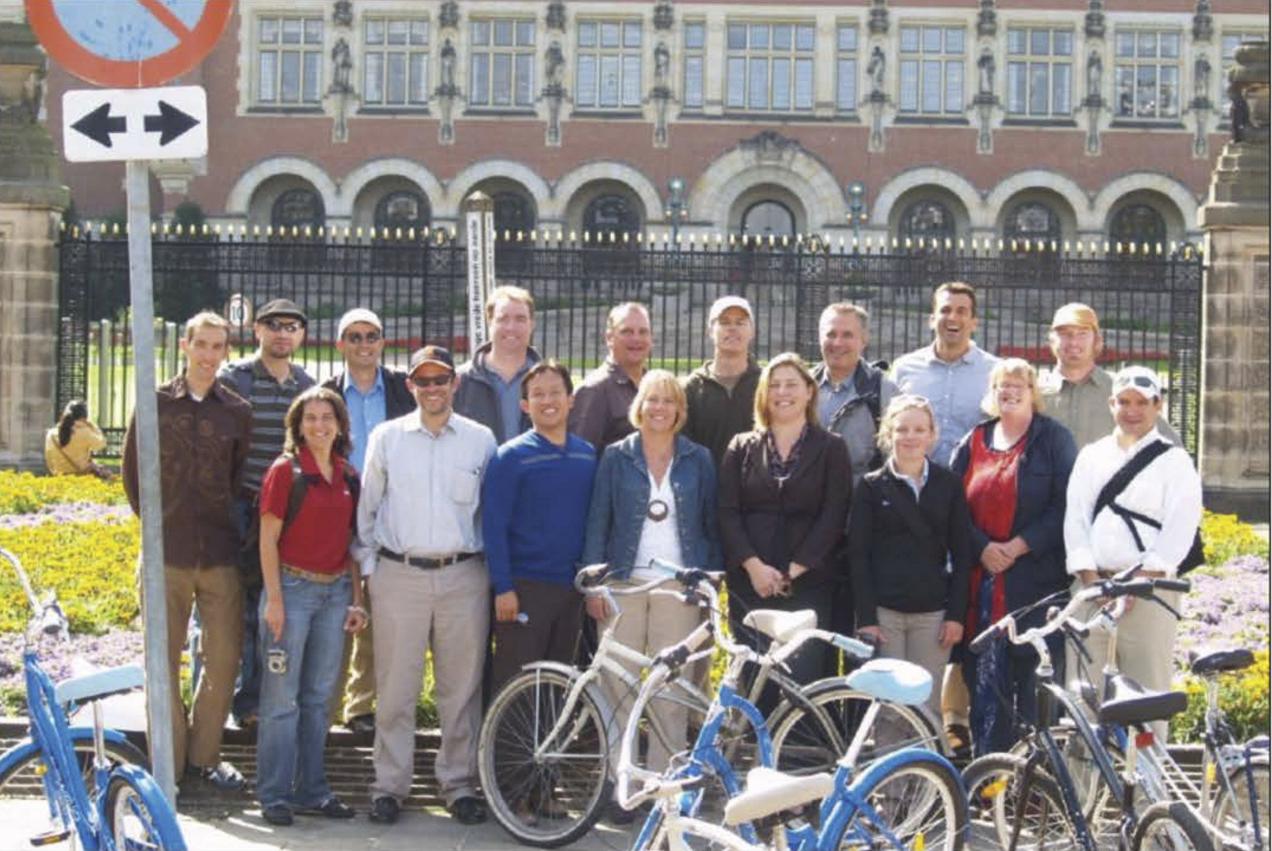
WTB-TAM led the ninth International Study Trip to the Netherlands in 2010. Delegates included San Francisco Board of Supervisors President David Chiu; San Francisco Chief Traffic Engineer Ricardo Olea; San Francisco Public Works Director Ed Reiskin; San Jose City Councilmember and later Mayor and US House member Sam Liccardo; San Jose Department of Transportation Deputy Director Manual Pineda; San Rafael Councilmember Damon Connolly; SMART Chief Engineer Bill Gamlen; Mill Valley Mayor Shawn Marshall; Corte Madera Councilmember Bob Ravasio; and Specialized Bicycles Advocacy Director Ian Dewar. The cities with delegates that joined this trip would become national leaders in bicycle transportation.

The Cal Park Hill Tunnel was built by the San Francisco & North Pacific Railroad in 1884 as part of an expansion of its Santa Rosa-to-San Rafael main line to a ferry terminal in Tiburon. Later merged to the Northwestern Pacific Railroad, the Cal Park Hill Tunnel fell into disuse and disrepair in the late 20th century. Today, it is one of only four tunnels in the United States to contain both an active railroad and a bike path. The concept originated with the 1994 North - South Bikeway Feasibility Study. When SMART began planning to restore and reopen the tunnel for trains, WTB-TAM got involved to make sure that the SMART Pathway (a.k.a. North - South Greenway) ran through the tunnel as well. When Marin County Supervisor Steve Kinsey asked Patrick Seidler “which tunnel do you want to open first?” Seidler responded “The Cal Park Hill Tunnel, because no one lives on top of it.” The pathway through the tunnel opened in 2010. SMART trains first carried passengers through the tunnel on their way between San Rafael and Larkspur on December 13, 2019. Reopening the tunnel cost $27 million total, including both the pathway and the train components. Today, the tunnel is one of the most popular and well-utilized segments of the SMART Pathway. It has transformed the connectivity of San Rafael and Larkspur, and significantly improved mobility for residents of the Canal neighborhood in San Rafael. It serves as model for opening other train tunnels such as the Alto Tunnel between Mill Valley and Corte Madera, the Bothin Tunnel between Fairfax and Woodacre, and the Reed Tunnel between Tiburon and Corte Madera.

Unfortunately, many returning delegates from WTB-TAM’s International Study Trips encountered resistance from their Public Works Departments, who told them that it was impossible to apply the Dutch best practices for active transportation design in the American context because there were no design guidelines for cycle tracks, roundabouts, and protected intersections. WTB-TAM brought this to the attention of PeopleForBikes, who allocated a budget and hired Zach Vanderkoy, a graduate of the Harvard Design School, to develop engineering guidelines to be used in the United States. WTB-TAM organized a meeting with PeopleForBikes and Alta Planning to work with US city members of the National Association of City Transportation Officials (NACTO) to develop a plan develop engineering guidelines. The result was NACTO’s Urban Bikeway Design Guide, first published in 2011 and updated several times since. Today, cities across the United States turn to the NACTO design guidelines to justify their multi-modal projects, and design innovations originally from the Netherlands, Northern Europe, and global best practices such as separated bike lanes and protected intersections are now part of the American transportation lexicon.
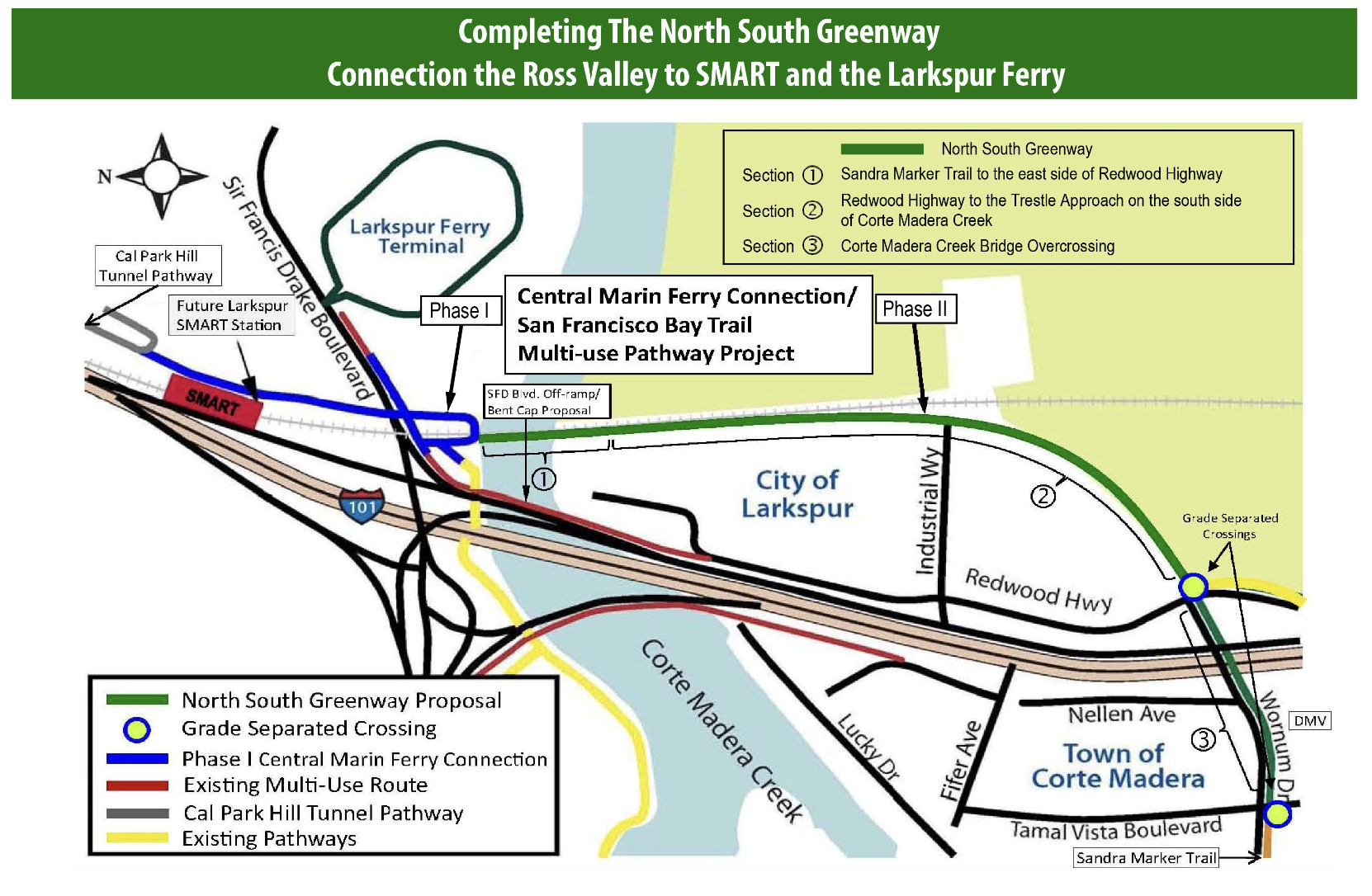
In 2013-2014, WTB-TAM led a coalition of local advocates to close the gap in the North – South Greenway between the north and south sides of Corte Madera Creek. Also known as the Central Marin Ferry Connection, this segment of the Greenway is a key connector for the Southern Marin communities south of Corte Madera Creek to access facilities north of Corte Madera Creek such as the SMART railroad, the Larkspur Ferry Terminal, and the Cal Park Hill Tunnel. WTB-TAM was instrumental in organizing the community to support the alternative that would locate the Greenway on the historic Northwestern Pacific Railroad right-of-way, and in obtaining resolutions of support from the communities of Larkspur and Corte Madera as well as local school districts. WTB-TAM also helped obtain funding for the project. Most of the Central Marin Ferry Connection has since been completed, but a key gap known as the Southern Segment of the North – South Greenway Gap Closure Project still remains unbuilt and is a central focus of WTB-TAM’s current advocacy.

During the International Study Trips to the Netherlands, WTB-TAM made contact with numerous transportation engineering and design professionals and firms. One of those firms was ipv Delft, world leaders in bicycle tunnels, bridges, and context-specific design in sensitive wetlands environments. WTB-TAM International Study Trip delegates were shown several of ipv Delft’s signature projects, including the Hovenring in Eindhoven. In 2015, WTB-TAM brought ipv Delft Senior Project Designers Adriaan Kok and Ivo Mulders to Marin County. During their time there, Adriaan and Ivo presented many conceptual designs for the North - South Greenway and other bicycle projects in the area, and delivered a lecture on Dutch bicycle path design in San Rafael City Council chambers.

In 2015, WTB-TAM started working with SMART and the City of San Rafael to design the Andersen Drive to Second Street segment of the SMART Pathway (a.k.a. North - South Greenway). This key segment would link downtown San Rafael to the Cal Park Hill Tunnel. Unfortunately, the General Manager of SMART at the time argued that there was not enough space within SMART’s right-of-way to build the pathway on this segment. WTB-TAM had to pull out the stops and convince SMART to follow through and build the Greenway alongside the train, as promised to the voters who approved Measure Q. WTB-TAM hired ipv Delft to do the engineering and illustrate that in fact the pathway could be built with the pathway cantilevered over the adjacent creek. In the end, WTB-TAM brought together leadership from San Rafael to work out a plan with SMART to convert East Francisco Boulevard to one-way traffic and build the Pathway alongside the railroad. The segment cost $9 million and opened in 2020.

In 2015, Patrick Seidler and Marin County Supervisor Steve Kinsey joined forces to create the North - South Greenway Business Plan, a map outlining the completed segments of the North - South Greenway (south of Larkspur) and the SMART Pathway (north of Larkspur), as well as the gaps. They took the Business Plan to the MTC (Metropolitan Transportation Commission) and used it to win $19.8 million in funding to complete gaps in the North - South Greenway in Marin County.

In 2018, WTB-TAM began a multi-year process advocating for best practices in multi-use path design on the Merrydale Road segment of the North San Rafael Promenade. This pathway is an essential connector between Northgate Shopping Center and the Marin Civic Center SMART station. In the near future, the aging Northgate Shopping Center will be transformed into Northgate Town Square, the largest housing redevelopment in Marin County history. The Merrydale Road segment of the North San Rafael Promenade is essential to making Northgate Town Square a successful transit-oriented development. WTB-TAM organized community members to advocate for a 12-foot bikeway adjacent to a 6-foot walkway along Merrydale Road. WTB-TAM provided the engineering drawings, made presentations at the San Rafael City Council, and obtained a promise from the developer of Northgate Town Square to partially fund construction of the project.
In 2018, WTB-TAM began a multi-year process to help shape the redesign of the the Golden Gate Bridge, Highway, and Transportation District’s San Rafael Transit Center in downtown San Rafael. WTB-TAM attended numerous meetings and workshops with the District and the City, putting forward its vision for the North – South Greenway running along Tamalpais Avenue through the Transit Center site. WTB-TAM’s unique contribution was to recommend separation of the bicycle path of travel from the pedestrian path of travel following Dutch best practices.

In 2019, WTB-TAM led the twelfth International Study Trip to the Netherlands. Delegates included Marin County Public Health Director Dr. Matt Willis; San Rafael Deputy Public Works Director Rafat Raie; San Anselmo Councilmember and later Marin County Supervisor Brian Colbert; San Anselmo Public Works Director Sean Condry; and Canal Alliance CEO Omar Carrera. The graduates of this trip would go on to implement cutting edge bicycle infrastructure in their communities.

In 2019, WTB-TAM began working on the East Blithedale Avenue Improvement Project in Mill Valley. WTB-TAM organized community advocates to recommend separated bicycle facilities as part of this roadway rehabilitation project on Mill Valley’s main arterial road and a “Dutch trick” called the “Millwood Left.” In particular, TAM recommended Class IV protected bike lanes on East Blithedale Avenue between Lomita Avenue and Tower Drive. The Mill Valley Department of Public Works said the bike lanes were not feasible. WTB-TAM then hired a traffic engineer and in two weeks returned the project plans to the City of Mill Valley showing that the bike lanes were, in fact, feasible. In 2022, the project was completed and Mill Valley gained its first ever protected bike lanes.

The San Rafael Connection is the name of a future segment of the North – South Greenway that will close the gap between the top of Puerto Suello Hill and North San Pedro Road. It is a key connection between Downtown San Rafael and North San Rafael. It is a segment of the SMART Pathway that SMART had put off for many years. In 2020, with TAM’s urging, SMART and the City of San Rafael agreed to fund a Feasibility Study. WTB-TAM played an integral role, bringing in its own team of engineers to analyze the complex conditions on the project site, which requires the pathway to traverse a 100-foot tall slope from the top of Puerto Suello Hill down into the railroad ravine. WTB-TAM created engineering drawings showing how the pathway could be built, to standard, using switchbacks, and avoiding removal of heritage trees. WTB-TAM took drone photos and hired ipv Delft to create renderings of its recommended improvements. WTB-TAM’s work was incorporated into the Feasibility Study, which was published in 2022, and WTB-TAM’s recommended alignment was chosen as the “Preferred Alignment.” WTB-TAM conducted extensive outreach to project neighbors, SMART Board members, and the San Rafael Bicycle and Pedestrian Advisory Committee, and in 2023 successfully convinced SMART to agree to budget $700,000 to design and bring the project to “shovel-ready status.”

In 2021, WTB-TAM developed a concept for a pedestrian and bicycle tunnel between Sausalito and the historically disadvantaged community of Marin City. This tunnel would serve as a Safe Route to School for Marin City students who attend school in Sausalito, and for whom the only current route to school is via an underpass beneath Highway 101. TAM conducted outreach with Marin City community stakeholders and discussed the feasibility of the tunnel with the Boring Company.

In 2021, WTB-TAM played an active role in the efforts of the Town of San Anselmo to redesign the intersection of Sir Francis Drake Boulevard, Red Hill Avenue, and Center Boulevard, known as “The Hub.” The Hub is also a key node on the Cross – Marin Bikeway, one of WTB-TAM’s long-term regional projects in Marin County. WTB-TAM worked closely with the San Anselmo Town Council, the San Anselmo Bicycle and Pedestrian Advisory Committee, and the project consultants to workshop various concepts to improve both traffic flow and bicycle and pedestrian access through this intersection of regional importance. One of the concepts advanced was for a grade-separated bicycle and pedestrian bridge inspired by the “Hovenring” in Eindhoven, Netherlands. This was the result of San Anselmo Councilmember, Brian Colbert having visited the Hovenring in person as part of WTB-TAM’s 2019 International Study Trip. In 2022, the San Anselmo Town Council voted to advance improvements include a grade-separated bridge and roundabout.

In 2021, WTB-TAM created detailed engineering concepts for each of the twelve interchanges along Highway 101 in Marin County in the Transportation Authority of Marin’s 101 Interchanges and Approaching Roadways Study. WTB-TAM’s concepts focused on improving bicycle and pedestrian safety and connectivity through the interchanges by utilizing design techniques such as protected bike lanes, protected intersections, and grade-separated pathways. WTB-TAM presented its concepts to Transportation Authority of Marin leadership, and continues to advocate for them to this day in the three interchanges chosen for advancement by the Transportation Authority.

The “San Rafael Crossroads” is a concept that WTB-TAM developed for a protected intersection at Lindaro Street and Andersen Drive in San Rafael. It is part of the Cross – Marin Bikeway. In 2021, TAM began designing in earnest engineering concepts for the Crossroads, as well as for the entire Andersen Drive and Lindaro Street corridors. TAM has presented this project to members of the San Rafael City Council and Department of Public Works and has lobbied to get it included in the San Rafael Capital Improvement Program and Bicycle and Pedestrian Plan update.

The segment of the North – South Greenway between Marin City and Mill Valley sits atop the historic Northwestern Pacific Railroad right-of-way on an embankment through the middle of Bothin Marsh. This segment is vulnerable to sea level rise, and the embankment on which it sits has been cited as negatively impacting the hydrology and ecology of Bothin Marsh. As a result, the OneTam coalition is planning to realign this segment of the North – South Greenway around the marsh rather than through it. WTB-TAM has been involved in the project since 2022 as a stakeholder and subject expert. WTB-TAM has met with the project managers, making recommendations based on best practices for a wider multi-use path with bicycle and pedestrian separation, and for ensuring that the connection between the project and the community of Tamalpais Valley is safe and seamless.

In 2022, a decade after WTB-TAM first contributed to the SMART Civic Center Station Area Plan, WTB-TAM was still advocating for improvements to make the SMART Civic Center Station the model mobility hub for the entire SMART system. WTB-TAM put together a conceptual plan featuring includes pathways and bike lanes radiating out from the SMART station in all directions. The Civic Center Station Mobility Hub is the crossroads of the North – South Greenway, the North – South Bikeway, the North San Rafael Promenade, the Rafael Meadows Pathway, and the San Francisco Bay Trail. WTB-TAM presented its vision to SMART staff and the SMART Board, the City of San Rafael, and community stakeholders such as Responsible Growth for Marin and the Terra Linda Homeowners Association. In 2024, SMART applied for the Safe Routes to Transit grant to build a parking lot, protected bike lanes, and a pick-up/drop-off zone at the mobility hub. Thanks to WTB-TAM’s perseverance, the developer of Northgate Town Square has promised to help fund construction of the North San Rafael Promenade component of the Civic Center Station mobility hub. All the pieces are coming together, thanks to WTB-TAM’s tireless efforts.

WTB-TAM has advocated for restoring the Alto Tunnel for bicycle and pedestrian use since the early 2000s. In 2022, WTB-TAM became a member of the Friends of Alto Tunnel Steering Committee. WTB-TAM attends FOAT’s monthly meetings, contributes to FOAT’s advocacy campaigns, and contributes maps, research, and analysis to bolster the cause. In 2024, WTB-TAM delivered a lecture on the Alto Tunnel to the Corte Madera Women’s Club.

The goal of the Paradise Drive Complete Streets Project is to build a multi-use pathway along Paradise Drive in East Corte Madera connecting to Ring Mountain Open Space and Marin Country Day School. In 2022, WTB-TAM worked with the Corte Madera Bicycle and Pedestrian Advisory Committee, attended public workshops, and submitted conceptual drawings with its recommendations for the pathway on the south side of Paradise Drive.

WTB-TAM has actively advocated for the last three years to complete a longstanding project from the San Rafael Bicycle and Pedestrian Master Plan: a multi-use path and protected bike lanes along Nova Albion Way in North San Rafael. This project would serve as school route to Vallecito Elementary School and Kaiser Permanente Hospital, and would connect to the Terra Linda High School pathway, which was completed in 2023. WTB-TAM has taken its advocacy on the project to the San Rafael Bicycle and Pedestrian Advisory Committee, the San Rafael Department of PublicWorks, and the Miller Creek School District Safe Routes to School Task Force.

WTB-TAM has been fighting for the completion of Marin’s Primary Active Transportation Network, of which the North – South Greenway and Cross – Marin Bikeway are the two main spines, for more than two decades. In 2022, WTB-TAM set out in conjunction with the Transportation Authority of Marin to document in detail the current status of these two primary routes and their remaining gaps. The result, the North – South Greenway and Cross – Marin Bikeway Gap Status Report, was published by the Transportation Authority of Marin in 2023 and serves as roadmap for finishing the respective bikeways.

When the Transportation Authority of Marin chose three interchanges from the Highway 101 Interchanges and Approaching Roadways Study to advance to design, it did not choose the Tamalpais Drive interchange in Corte Madera. Nevertheless, Caltrans had a project in development for the Tamalpais Drive interchange to address seismic safety and non-ADA- compliant pedestrian ramps. The Town of Corte Madera saw the Caltrans project as an excellent opportunity to achieve a longtime goal: a multi-use pathway across Highway 101 connecting the east and west halves of Corte Madera. WTB-TAM jumped into action, working with the Corte Madera Town Council, Department of Public Works, and Bicycle and Pedestrian Advisory Committee to explain the differences between the various alternatives developed by Caltrans and to make recommendations for the best possible outcome. As a result, the Town of Corte Madera was able to identify enough money from its own General Fund and grant awards to cover the difference between the bare-bones alternative that Caltrans was willing to pay for, and the more expensive alternative containing the multi-use path. The project goes to construction in 2026.

Since 2022, WTB-TAM has been an active member of Active Mill Valley, a coalition of active transportation advocates, engineers, Bicycle and Pedestrian Advisory Committee members, and elected officials dedicated to building out Mill Valley’s active transportation network and increasing the share of trips made by active modes instead of driving. As a member of Active Mill Valley, WTB-TAM has shared its expertise on best practices in design and advocacy, and provided pro bono to the City of Mill Valley the Mill Valley Bicycle Parking Study, the Mill Valley Intersection Study, GIS work supporting Mill Valley’s application for the League of American Bicyclists’ “Bicycle Friendly City” designation, and leading the steering committee responsible for the Mill Valley Bicycle and Pedestrian Master Plan Addendum.

In 2022, WTB-TAM provided pro bono to the City of Mill Valley the Mill Valley Bicycle Parking Study, a survey of existing conditions including number and type of all public-facing bicycle parking at schools, public facilities, and private businesses. The study also makes recommendations for improvements to existing bicycle parking and locations for installation of new bicycle parking. As a result of WTB-TAM’s recommendations, the City is now installing new bicycle parking at Mill Valley City Hall and Boyle Park.

The Rafael Meadows Pathway is an important component of the Civic Center Mobility Hub. It will provide a bicycle and pedestrian route for residents and students of the Rafael Meadows neighborhood in San Rafael beneath Highway 101, providing access to the Civic Center SMART Station, Venetia Valley K-8 School, the Marin County Civic Center, the Marin County Farmer’s Market, and the Marin County Fairgrounds. TAM took drone photos and hired ipv Delft to create renderings of the proposed pathway, which originated in the San Rafael Safe Routes to School Task Force. In 2023, with TAM’s help, the City of San Rafael successfully won a $1.9 million grant from the US Department of Transportation to design and build the Rafael Meadows Pathway.

WTB-TAM had previously recommended a multi-use path and protected bike lanes along Tiburon Boulevard as part of the 2016 Tiburon Bicycle and Pedestrian Master Plan. When Caltrans began planning a roadway rehabilitation project on Tiburon Boulevard (a.k.a. State Route 131) in 2023, WTB-TAM lobbied Caltrans to include these multi-modal improvements as part of the project. TAM created engineering drawings, took drone photos, and hired ipv Delft to create renderings of its recommended improvements. WTB-TAM then conducted outreach to Caltrans leadership, the Tiburon Town Council, the Tiburon Safe Routes to School Task Force, and several Homeowners Associations along the project corridor. As of 2024, Caltrans is still designing the project, and it appears that most of WTB-TAM’s recommendations are being incorporated into the project final design.

TAM was a member of the Bay Trail Gap Closure Working Group for the development of a plan to identify and prioritize all the remaining gaps in the San Francisco Bay Trail. In 2023, WTB-TAM attended meetings at MTC headquarters in San Francisco and made recommendations to the methodology for ranking the gaps in order of priority.
In 2023, WTB-TAM conducted extensive outreach and advocacy with the Sausalito City Council and Pedestrian and Bicycle Advisory Committee to advance completion of the North – South Greenway in the City of Sausalito. TAM identified grant funding opportunities for the city, and created conceptual plans for the Greenway segments between Harbor Drive and Gate 6 Road and between Napa Street and Johnson Street. In 2024, WTB-TAM helped the City prepare an application for multiple pathway segments for the Safe Routes to Transit and Bay Trail grant program.

In 2023, WTB-TAM provided pro bono GIS analysis services to the City of Mill Valley to support the city’s application to the League of American Bicyclists to renew its “Bicycle Friendly City” designation. As a result of WTB-TAM’s contributions, the City successfully won “Silver” status from the League.

For the segment of the SMART pathway that crosses Novato Creek, SMART was originally planning to utilize an on-street alignment along existing roadways across the Creek. In 2023, WTB-TAM conducted historical research to show SMART how its original plans called for a new pathway bridge across Novato Creek parallel to the railroad bridge. WTB-TAM hired ipv Delft to create conceptual designs for a new pathway bridge. As a result, SMART agreed to change its planned pathway alignment and include the pathway bridge in its plans.

In addition to bicycle and pedestrian advocacy, WTB-TAM supports other transportation alternatives such as buses, trains, and ferries. The Golden Gate Bridge, Highway, and Transportation District’s ferry service between Larkspur and San Francisco has WTB-TAM’s strong support. The Larkspur Ferry Terminal is located along the North – South Greenway, at the intersection of the Greenway and the Corte Madera Creek Path. It is ideally situated for access by bike. It also sits next to the SMART Larkspur Station, and thus is easily accessible by train. Unfortunately, the Bridge District believes that in order to increase ferry ridership, it must double its existing 2,000-car parking lot to accommodate 4,000 cars. In 2023, WTB-TAM began working to demonstrate to the Bridge District, Transportation Authority of Marin, and local stakeholders that expanding the parking lot is not necessary and that there are better ways to increase access to the Larkspur Ferry Terminal. These include shuttle bus service, completing gaps in the North – South Greenway, installing secure bike parking at the ferry terminal, offering price incentives to ferry riders who ride their bikes to the ferry terminal by bike, bikeshare hubs at and around the ferry terminal, and a bike lease program aimed at ferry riders paired with incentives.

One of the three interchanges from the Transportation Authority of Marin’s Highway 101 Interchanges and Approaching Roadways Study to be advanced to the design stage is the Nave Drive interchange in Novato. In 2023, WTB-TAM created a conceptual engineering plan for grade-separated passage of the North – South Bikeway pathway through the interchange using a design similar to the one WTB-TAM contributed to the Lincoln Avenue interchange a decade earlier. WTB-TAM took drone photos and hired ipv Delft to create renderings of its proposal, which it presented to the Transportation Authority and its consultant team.

In 2024, WTB-TAM contributed to the first ever Marin Countywide Transportation Plan. WTB-TAM’s contributions centered on the definition and mapping of the Primary Active Transportation Network and the prioritization of projects for near-term completion.

In 2024, WTB-TAM provided pro bono to the City of Mill Valley the Mill Valley Intersection Study, a survey of all arterial street intersections in the city, focusing on analysis of curb radii. The study recommends tightening all curb radii over 15 feet to shorten pedestrian crossing distances and slow down turning vehicles, improving pedestrian safety. These modifications can be made using Quick Build methods (i.e. “paint and plastic”) which offer significant cost savings compared to traditional methods.

TAM is a “Shareholder” in the Petaluma River Park. In 2024, WTB-TAM has attended multiple Shareholder Workshops to take part in the planning and design of a new regional park spanning both banks of the Petaluma River. WTB-TAM’s particular area of expertise in this process is in circulation and pathway design. The proposed pathway running through the park, and across a new bridge over Petaluma River, has the potential to close a major gap in the SMART Pathway alignment through the City of Petaluma.

In 2024, WTB-TAM played an advisory role in the development of the SMART 2025-2029 Strategic Plan, attending public workshops and offering recommendations to SMART for strategies to complete the SMART Pathway, increase ridership, and address SMART’s first-and-last-mile needs. As part of the first-and-last-mile needs analysis, TAM used GIS and US Census data to create a detailed set of maps depicting the 1- mile radius area around each of 16 SMART stations (existing and planned) in Marin and Sonoma Counties. The maps show detailed, block-level population density and job density overlaid with bus routes and existing and planned bikeways and pathways.

WTB-TAM is a member of Walk Bike San Rafael, a local advocacy organization focused on pedestrian and bicycle improvements in San Rafael. San Rafael currently lacks a separated bike route running east-to-west through its downtown. WTB-TAM chairs Walk Bike San Rafael’s east-west corridor subcommittee. In 2024, WTB-TAM conducted a Feasibility Study looking at what would be necessary to install either Class II bike lanes or Class IV protected bike lanes on Fourth Street or Fifth Avenue through Downtown San Rafael. The Study identifies required modifications to on-street parking, curb extensions, turn lanes, and parklets under a variety of different scenarios. As part of the Study, WTB-TAM also conducted multiple traffic counts on both corridors to identify typical parking usage rates.

The Great Redwood Trail is the brainchild of California State Senate President Pro Tempore Mike McGuire. It is a rail-to-trail pathway project that follows the historic Northwestern Pacific Railroad right-of-way from Larkspur in Marin County to Blue Lake in Humboldt County. The southern portion of the Great Redwood Trail overlaps with the SMART Pathway. In 2024, WTB-TAM worked with the Marin County Bicycle Coalition, the Great Redwood Trail Authority, and Senator McGuire to extend the Great Redwood Trail south of Larkspur to encompass the full length of the North – South Greenway all the way to the Golden Gate Bridge.

Butterfield Road is the main arterial street serving the community of Sleepy Hollow in unincorporated Marin County. In 2024, WTB-TAM worked with the Marin County Department of Public Works, the Marin County Board of Supervisors, and neighborhood advocates to recommend bicycle and pedestrian improvements such as protected intersections to the Butterfield Road corridor to improve bicycle and pedestrian safety and calm traffic.

Davidson Middle School is the largest middle school in Marin County with over 1,000 students, many of them from the low-income Canal neighborhood. Unfortunately, Davidson lacks safe bicycle infrastructure, and as a result has one of the lowest rates of biking to school of any middle school in the county. In 2024, WTB-TAM conducted several site visits with members of the San Rafael Safe Routes to School Task Force to develop counts of school traffic by mode and identify current issues and challenges. WTB-TAM developed a Master Plan to improve safe access to Davidson Middle School including new pathways on Lindaro Street and Jordan Street and new crosswalks and curb extensions.

In 2024, WTB-TAM stepped up its planning efforts in support of the Southern Segment of the North – South Greenway Gap Closure Project, a perennial project it had been involved in for many years. WTB-TAM engaged in community organizing, turning out activists to speak in support of the project at TAM meetings, obtained Resolutions from multiple public agencies and school districts, conducted analysis of leases affecting the project, and undertook extensive design and engineering work to show that the project is feasible and can be delivered at low cost.